Bodies of Water[]
Western Hadrian Ocean - The largest ocean on New Luna, it covers a wide band to the north of Freedom City.
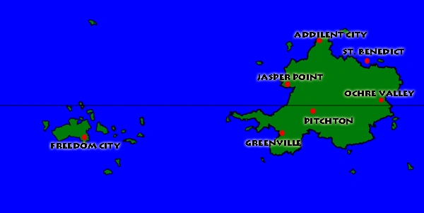
Eastern Hadrian Ocean - Hugs the northwestern coast of the main continent, near Jasper Point.
Southern Hadrian Ocean - Covers much of the Southern hemisphere between Freedom City and Greenville.
Ultramarine Ocean - The second-largest ocean on New Luna, it covers the space between the eastern side of the main continent and Freedom City.
Frost Ocean - The ocean covering much of New Luna's north pole.
Crystalnight Sea - The sea surrounding the Freedom archepelago.
Kingfisher Sea - A sea on the northeast edge of the main continent.
Veridican Bay - A bay shaped like an upside-down V, just south of Pitchton.
Hecatia Bay - A broad bay, southwest of Jasper Point.
Reverencial Lake - A C-shaped lake east of Pitchton.
Mountains[]
Mount Plaindid - The second-tallest mountain on New Luna at around 33,000 miles high. It is situated east of Greenville and south-southwest of Pitchton.
Mount Gilead - The tallest mountain on New Luna at approximately 35,400 miles high. It is just southwest of St. Benedict.
Queen's Mountain - Rising up on the north end of Deepcrest Island, it is a respectable 21,100 miles high.
Landmarks[]
Naismith's Pass (Coloquially Naismith's Notch) - A half-mile wide pass between mountains on the path from Greenville to Pitchton.
Miracle Rock - A 100-foot long boulder inexplicably suspended on a 12 foot wide pinnacle of rock jutting out of the Kingfisher Sea.
The Sweat Belt - A strip of land northeast of Pitchton with perpetual jungle-like conditions due to the tall mountains nearby that catch rainclouds.
Devil's Panties - A badlands region about 1000 miles north of Ochre Valley.
The Dark - A cavern system near St. Benedict that is known to sprawl over hundreds of miles, most of which is unexplored.
Map of New Luna featuring its seven city-states